“E-9” International seaside hiking trail
The E-9 Baltic Red Hiking Trail, famous for many years, is, in Świnoujście and the surrounding areas, not of uniform character – it runs partially by the Reservoir, partially by the sea, partially through the forest and partially through the city. The only common denominator is that it almost always runs through peaceful areas.
The trail begins by the Świnoujście – Ahlbeck border crossing and soon breaks off from the main, Wojska Polskiego Street, in the direction of the sea. In this way, we travel directly from the crowded and loud border market, to the quiet outlying areas of the city. Here, we will feel almost as if we were in a forest, as building are sparingly visible in this section of the trail. Even if we see buildings, they are usually covered by the surrounding natural vegetation. The trail turns east and soon reaches the first buildings of the Seaside District.
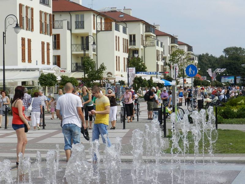
THE SEASIDE DISTRICT – The most beautiful district in Świnoujście. Art nouveau guest-houses located by the alleys and sheltered by chestnut and plane trees create the glamorous climate of a seaside health resort. For over a century, life here has had a completely different rhythm. You will walk through a bright, spacious and almost always crowded promenade and be rewarded by a view of the most representational guest-houses in Świnoujście. Passing the band-shell, you will then enter a new part of the promenade, which begins with a fountain that is illuminated at night. You can also rest by choosing a bench or a seat in one of the numerous cafes or restaurants in this part of the promenade. As they end, the congested housing ends with them. The trail now runs through Uzdrowiskowa Street, on the way passing a large hotel complex, behind which spreads a vast forest area.
Breaking off into a sand dune area, you can see abandoned bunkers and concrete structures of various shapes, the purpose of which is often hard to guess. Most of these are remnants of the radar-equipped anti-aircraft battery built here by the Nazis.
RADARS IN ŚWINOUJŚCIE – the sand dunes at Uzdrowiskowa Street were used by Hitler’s secret radio-location unit. This is where they built powerful radars, capable of picking up targets in the area of up to 50 km and precisely pinpointing them for the artillery. According to the thesis of a researcher of fortifications in Świnoujście, P. Laskowski, the unit performed, among others, experimental tasks. Most likely, among their research were the flight trajectories of V1 rockets and tests of infrared observation systems functioning in tandem with the radars.
Next, the trail moves away from the sea, going along the Świna river to the western fort complex.
THE WESTERN FORT – this protected the entrance to the port in Świnoujście by use of heavy cannons (it was fortified with 210 and 150 mm cannons). Its construction began in 1843. From that time forward, for 121 years, it ceaselessly performed military functions – first for the Prussian army, then for Hitler’s army, and finally for the Soviets. Currently, its grounds, among others, host the largest exhibit of military excavations in Świnoujście.
THE ANGEL’S FORT – the most filigree fort of the 19th-Century Świnoujście Stronghold, built between 1855-58. It had less significance in combat; however, it performed a crucial communications function in the complex of four port strongholds in Świnoujście (apart from the Angel’s Fort, it was composed of the Eastern and Western Forts, as well as the eastern Port Stronghold - which was demolished after the war during the construction of the Port of Świnoujście). Before World War II, Angel's Fort functioned as Hitler’s air defence command for Świnoujście – a remnant of that period is the concrete extension, where a radar antenna was located.
The next section of the trail, paved with brick, leads through Jachtowa Street, and runs near the shore of the North Basin. The basin once served as a dry shipyard dock (drained of water using a special barrier and a system of pumps). Currently, it is a modern yacht port for 400 units. The red brick structures are part of the complex of 19th-Century buildings and depots that made up former shipyard, including a characteristic water tower. A little further along, the trail passes a landmark building of the Port Authority – one of the favourite painting and postcard motifs of the turn of the 20th Century. It is the central seashore of the city – the Coast of Władysław IV.
THE COAST OF WŁADYSŁAW IV – the active and very wide, main “waterway junction” of Świnoujście. “Bielik” municipal ferries, which shuttle all day long, must at times give priority to ships travelling through Świna. Tugboats and fireboats, as well as occasionally other very interesting units, constantly moor at the quay. Nearby, you can also find a military port.
A short while after that you will reach the crossing point for the Wolin island – a terminal for the “Bielik” ferries. However, if the time allows for it, you should visit the Maritim Fishing Museum before crossing to the other shore. It is located only a few hundred meters further, near the Fisherman’s Square.


Date Added 03 August 2012